Geolocate

Vis topographic map

Click on the map to display elevation.

About this map

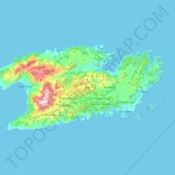
Name: Vis topographic map, elevation, terrain.

Location: Vis, Grad Vis, Split-Dalmatia County, Croatia (43.00514 16.04890 43.08161 16.25811)

Average elevation: 51 m

Minimum elevation: -1 m

Maximum elevation: 576 m

Gear up for your next adventure:

🧷Tenacious Repair Tape - Instant fix for torn tents, jackets, or dry bags
🧢Waterproof Hiking Hats - Keep the rain off your face while studying topographic maps
🧣Neck Gaiters - Versatile protection against wind and cold
🛌Sleeping Mats - Insulated mats for comfortable outdoor sleeping
🥾Trekking Poles - Poles to improve stability on uneven terrain

As an Amazon Associate, this site earns from qualifying purchases at no extra cost to you.