
Heverlee topographic map
Interactive map
Click on the map to display elevation.
About this map
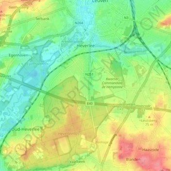
Name: Heverlee topographic map, elevation, terrain.
Location: Heverlee, Leuven, Flemish Brabant, Flanders, 3001, Belgium (50.82421 4.64030 50.87922 4.72768)
Average elevation: 49 m
Minimum elevation: 16 m
Maximum elevation: 97 m
Other topographic maps
Click on a map to view its topography, its elevation and its terrain.
Wilsele
Belgium > Flemish Brabant > Leuven > Leuven
Wilsele, Leuven, Flemish Brabant, Flanders, 3012, Belgium
Average elevation: 25 m
Leuven
Belgium > Flemish Brabant > Leuven > Leuven
Leuven, Flemish Brabant, Flanders, 3000, Belgium
Average elevation: 50 m