
Thank you for supporting this site ❤️
Make a donation
Make a donation
Gear up for your next adventure:
As an Amazon Associate, this site earns from qualifying purchases at no extra cost to you.
Shinshicho topographic map
Click on the map to display elevation.
Thank you for supporting this site ❤️
Make a donation
Make a donation
Gear up for your next adventure:
As an Amazon Associate, this site earns from qualifying purchases at no extra cost to you.
About this map
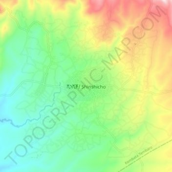
Name: Shinshicho topographic map, elevation, terrain.
Location: Shinshicho, Kembata Alaba Tembaro, Southern Nations, Ethiopia (7.16616 37.73689 7.24616 37.81689)
Average elevation: 1,893 m
Minimum elevation: 1,698 m
Maximum elevation: 2,240 m
Thank you for supporting this site ❤️
Make a donation
Make a donation
Gear up for your next adventure:
As an Amazon Associate, this site earns from qualifying purchases at no extra cost to you.