Geolocate

Bunkie topographic map

Click on the map to display elevation.

About this map

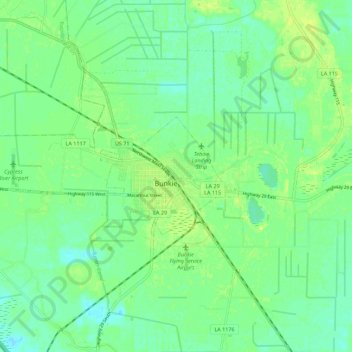
Name: Bunkie topographic map, elevation, terrain.

Location: Bunkie, Avoyelles Parish, Louisiana, United States (30.93884 -92.27402 30.97098 -92.16275)

Average elevation: 18 m

Minimum elevation: 10 m

Maximum elevation: 27 m

Other topographic maps

Click on a map to view its topography, its elevation and its terrain.

Hamburg

United States > Louisiana > Avoyelles Parish

Average elevation: 15 m

Gear up for your next adventure:

📱Phone Mounts for Hiking - Secure mounts to carry your phone on trails
🔪Outdoor Multi-Tools - Versatile tools for gear repairs and food prep in the wild
🎒Replacement Sternum Straps - Repair parts for hiking rucksacks
🧺Ultralight Dry Bags - Organize and waterproof your gear inside your rucksack
👕Technical Hiking Tees - Moisture-management for high-exertion climbs

As an Amazon Associate, this site earns from qualifying purchases at no extra cost to you.