Geolocate

Solothurn topographic map

Interactive map

Click on the map to display elevation.

About this map

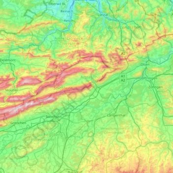
Name: Solothurn topographic map, elevation, terrain.

Location: Solothurn, Switzerland (47.07434 7.34041 47.50270 8.03137)

Average elevation: 593 m

Minimum elevation: 275 m

Maximum elevation: 1,427 m

Other topographic maps

Click on a map to view its topography, its elevation and its terrain.

Hochwald

Switzerland > Solothurn > Amtei Dorneck-Thierstein

Hochwald, Bezirk Dorneck, Amtei Dorneck-Thierstein, Solothurn, 4146, Switzerland

Average elevation: 615 m

Aeschi (SO)

Switzerland > Solothurn > Amtei Bucheggberg-Wasseramt

Aeschi (SO), Bezirk Wasseramt, Amtei Bucheggberg-Wasseramt, Solothurn, 4556, Switzerland

Average elevation: 492 m

Grenchen

Switzerland > Solothurn > Amtei Solothurn-Lebern

Grenchen, Bezirk Lebern, Amtei Solothurn-Lebern, Solothurn, 2540, Switzerland

Average elevation: 705 m

Witterswil

Switzerland > Solothurn > Amtei Dorneck-Thierstein > Witterswil

Witterswil, Bezirk Dorneck, Amtei Dorneck-Thierstein, Solothurn, 4108, Switzerland

Average elevation: 383 m

Oberbuchsiten

Switzerland > Solothurn > Amtei Thal-Gäu > Oberbuchsiten

Oberbuchsiten, Bezirk Gäu, Amtei Thal-Gäu, Solothurn, 4625, Switzerland

Average elevation: 583 m

Olten

Switzerland > Solothurn > Amtei Olten-Gösgen > Olten

Olten, Bezirk Olten, Amtei Olten-Gösgen, Solothurn, Switzerland

Average elevation: 475 m

Dornach

Switzerland > Solothurn > Amtei Dorneck-Thierstein

Dornach, Bezirk Dorneck, Amtei Dorneck-Thierstein, Solothurn, 4143, Switzerland

Average elevation: 397 m