Geolocate

Dela Paz topographic map

Click on the map to display elevation.

About this map
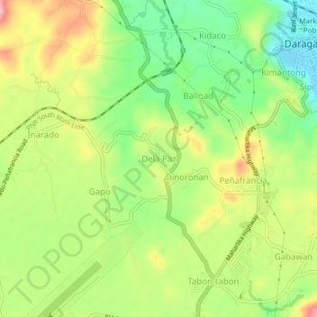
Name: Dela Paz topographic map, elevation, terrain.

Location: Dela Paz, Daraga, Albay, Bicol Region, 4501, Philippines (13.11341 123.67360 13.15341 123.71360)

Average elevation: 89 m

Minimum elevation: 23 m

Maximum elevation: 168 m

Other topographic maps

Click on a map to view its topography, its elevation and its terrain.

Yawa River

Philippines > Albay > Daraga > Busay

Average elevation: 47 m

Cagsawa Ruins Park

Philippines > Albay > Daraga > Busay

Average elevation: 68 m

Gear up for your next adventure:

🧰First Aid Kits - Essential safety kits for outdoor activities
🎒Hiking Daypacks - Compact backpacks ideal for short hikes and excursions
⛺Lightweight Tents - Compact tents for backpacking and trekking
🧭Orienteering Compasses - Accurate compasses for map-based navigation
🥾Trekking Poles - Poles to improve stability on uneven terrain

As an Amazon Associate, this site earns from qualifying purchases at no extra cost to you.