
Mulhouse topographic map
Interactive map
Click on the map to display elevation.
About this map
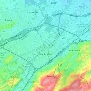
Name: Mulhouse topographic map, elevation, terrain.
Location: Mulhouse, Haut-Rhin, Grand Est, Metropolitan France, France (47.72188 7.28249 47.78337 7.36863)
Average elevation: 254 m
Minimum elevation: 229 m
Maximum elevation: 337 m
Other topographic maps
Click on a map to view its topography, its elevation and its terrain.
Thannenkirch
France > Grand Est > Haut-Rhin
Thannenkirch, Colmar-Ribeauvillé, Haut-Rhin, Grand Est, Metropolitan France, 68590, France
Average elevation: 580 m
Wanne
France > Grand Est > Haut-Rhin > Dietwiller
Wanne, Dietwiller, Mulhouse, Haut-Rhin, Grand Est, Metropolitan France, 68440, France
Average elevation: 282 m
Saint-Ulrich
France > Grand Est > Haut-Rhin
Saint-Ulrich, Altkirch, Haut-Rhin, Grand Est, Metropolitan France, 68210, France
Average elevation: 367 m
Les Hauts de Lucelle
France > Grand Est > Haut-Rhin > Lucelle
Les Hauts de Lucelle, Lucelle, Altkirch, Haut-Rhin, Grand Est, Metropolitan France, 68480, France
Average elevation: 676 m
Michelbach
France > Grand Est > Haut-Rhin > Aspach-Michelbach
Michelbach, Aspach-Michelbach, Thann-Guebwiller, Haut-Rhin, Grand Est, Metropolitan France, 68700, France
Average elevation: 338 m
Oberhergheim
France > Grand Est > Haut-Rhin > Oberhergheim
Oberhergheim, Thann-Guebwiller, Haut-Rhin, Grand Est, Metropolitan France, 68127, France
Average elevation: 202 m
Rueti
France > Grand Est > Haut-Rhin > Schlierbach
Rueti, Schlierbach, Mulhouse, Haut-Rhin, Grand Est, Metropolitan France, 68440, France
Average elevation: 260 m
Soultzeren
France > Grand Est > Haut-Rhin > Soultzeren
Soultzeren, Colmar-Ribeauvillé, Haut-Rhin, Grand Est, Metropolitan France, 68140, France
Average elevation: 843 m
Wasserbourg
France > Grand Est > Haut-Rhin > Wasserbourg
Wasserbourg, Colmar-Ribeauvillé, Haut-Rhin, Grand Est, Metropolitan France, 68230, France
Average elevation: 729 m
Masevaux
France > Grand Est > Haut-Rhin > Masevaux-Niederbruck
Masevaux, Masevaux-Niederbruck, Thann-Guebwiller, Haut-Rhin, Grand Est, Metropolitan France, 68290, France
Average elevation: 577 m
Kermode
France > Grand Est > Haut-Rhin > Lapoutroie > Froide Fontaine
Kermode, Froide Fontaine, Lapoutroie, Colmar-Ribeauvillé, Haut-Rhin, Grand Est, Metropolitan France, 68650, France
Average elevation: 627 m
Berges de la Birsig
France > Grand Est > Haut-Rhin > Leymen > Berges de la Birsig
Berges de la Birsig, Leymen, Mulhouse, Haut-Rhin, Grand Est, Metropolitan France, 68220, France
Average elevation: 400 m
Vosges
France > Grand Est > Haut-Rhin > Goldbach-Altenbach
Vosges, Goldbach-Altenbach, Thann-Guebwiller, Haut-Rhin, Grand Est, Metropolitan France, 68760, France
Average elevation: 864 m
Soultz-Haut-Rhin
France > Grand Est > Haut-Rhin
Soultz-Haut-Rhin, Thann-Guebwiller, Haut-Rhin, Grand Est, Metropolitan France, 68360, France
Average elevation: 346 m
Berentzwiller
France > Grand Est > Haut-Rhin
Berentzwiller, Altkirch, Haut-Rhin, Grand Est, Metropolitan France, 68130, France
Average elevation: 404 m