Geolocate

Portobello topographic map

Click on the map to display elevation.

About this map

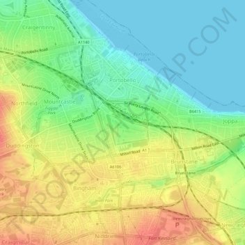
Name: Portobello topographic map, elevation, terrain.

Location: Portobello, City of Edinburgh, Scotland, United Kingdom (55.93519 -3.12857 55.96002 -3.07495)

Average elevation: 24 m

Minimum elevation: 0 m

Maximum elevation: 52 m

Scotland trails, hiking, mountain biking, running and outdoor activities

Other topographic maps

Click on a map to view its topography, its elevation and its terrain.

Ratho

United Kingdom > Scotland > City of Edinburgh

Average elevation: 80 m

Hillend

United Kingdom > Scotland > City of Edinburgh > Ratho

Average elevation: 67 m

Gogar

United Kingdom > Scotland > City of Edinburgh

Average elevation: 51 m

Newbridge

United Kingdom > Scotland > City of Edinburgh

Average elevation: 54 m

Crow Hill

United Kingdom > Scotland > City of Edinburgh

Average elevation: 68 m

Hillend

United Kingdom > Scotland > City of Edinburgh > Ratho

Average elevation: 67 m

Gogarbank

United Kingdom > Scotland > City of Edinburgh

Average elevation: 69 m

Gear up for your next adventure:

🔋Solar Power Banks - Keep your GPS and phone charged during multi-day expeditions
🔦Outdoor Torches - Reliable torches for night navigation
📍Handheld GPS Navigators - Reliable satellite navigation for hiking and off-road exploration
🧼Technical Clothing Wash - Special soap to clean and restore waterproof membranes
🚲Cycling GPS Computers - Track elevation and topographic routes on two wheels

As an Amazon Associate, this site earns from qualifying purchases at no extra cost to you.