
Gampaha topographic map
Interactive map
Click on the map to display elevation.
About this map
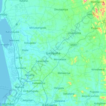
Name: Gampaha topographic map, elevation, terrain.
Location: Gampaha, Gampaha District, Western Province, 58.8, Sri Lanka (6.93256 79.83514 7.25256 80.15514)
Average elevation: 24 m
Minimum elevation: -1 m
Maximum elevation: 229 m
Other topographic maps
Click on a map to view its topography, its elevation and its terrain.
Indigolla
Sri Lanka > Western Province > Gampaha
Indigolla, Gampaha, Gampaha District, Western Province, 11875, Sri Lanka
Average elevation: 20 m