
Erftstadt topographic map
Interactive map
Click on the map to display elevation.
About this map
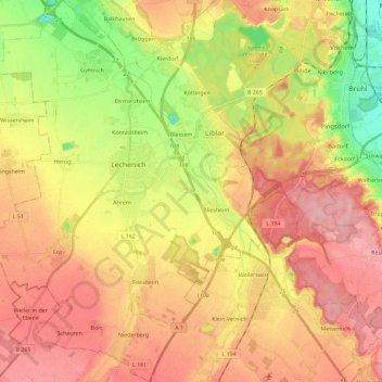
Name: Erftstadt topographic map, elevation, terrain.
Average elevation: 118 m
Minimum elevation: 52 m
Maximum elevation: 168 m
Other topographic maps
Click on a map to view its topography, its elevation and its terrain.
Oberaußem
Germany > North Rhine-Westphalia > Rhein-Erft-Kreis > Bergheim
Oberaußem, Bergheim, Rhein-Erft-Kreis, North Rhine-Westphalia, 50129, Germany
Average elevation: 84 m
Wesseling
Germany > North Rhine-Westphalia > Rhein-Erft-Kreis
Wesseling, Rhein-Erft-Kreis, North Rhine-Westphalia, 50389, Germany
Average elevation: 55 m
Türnich
Germany > North Rhine-Westphalia > Rhein-Erft-Kreis > Kerpen
Türnich, Kerpen, Rhein-Erft-Kreis, North Rhine-Westphalia, 50169, Germany
Average elevation: 93 m
Frechen
Germany > North Rhine-Westphalia > Rhein-Erft-Kreis
Frechen, Rhein-Erft-Kreis, North Rhine-Westphalia, 50226, Germany
Average elevation: 88 m