
Make a donation
Gear up for your next adventure:
As an Amazon Associate, this site earns from qualifying purchases at no extra cost to you.
Soportújar topographic map
Click on the map to display elevation.
Make a donation
Gear up for your next adventure:
As an Amazon Associate, this site earns from qualifying purchases at no extra cost to you.
About this map
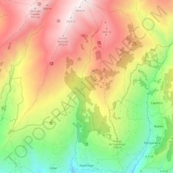
Name: Soportújar topographic map, elevation, terrain.
Average elevation: 1,867 m
Minimum elevation: 702 m
Maximum elevation: 3,080 m
Make a donation
Gear up for your next adventure:
As an Amazon Associate, this site earns from qualifying purchases at no extra cost to you.
Other topographic maps
Click on a map to view its topography, its elevation and its terrain.
Cortijo ruinas
Spain > Andalusia > Comarca de la Alpujarra Granadina > Capileira
Average elevation: 2,246 m
Sierra Nevada
Spain > Andalusia > Comarca de la Alpujarra Granadina > Lanjarón
Average elevation: 2,223 m
El Encinarillo
Spain > Andalusia > Comarca de la Alpujarra Granadina > Válor
Average elevation: 1,717 m
Make a donation
Gear up for your next adventure:
As an Amazon Associate, this site earns from qualifying purchases at no extra cost to you.
Pico de Mulhacén
Spain > Andalusia > Comarca de la Alpujarra Granadina > Trevélez
Mulhacén ([mulaˈθen]), with an elevation of 3,482 metres (11,424 ft), is the highest mountain in peninsular Spain and in all of the Iberian Peninsula. It is part of the Sierra Nevada range in the Penibaetic System. It is named after Abu'l-Hasan Ali, known as Muley Hacén in Spanish, the penultimate Muslim…
Average elevation: 3,070 m
Pico del Veleta
Spain > Andalusia > Comarca de la Alpujarra Granadina > Capileira
The IRAM 30m telescope is located on the slopes of Pico Veleta, at an elevation of 2920 m.
Average elevation: 2,998 m