
Steinhöring topographic map
Interactive map
Click on the map to display elevation.
About this map
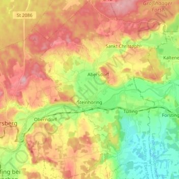
Name: Steinhöring topographic map, elevation, terrain.
Location: Steinhöring, Landkreis Ebersberg, Bavaria, 85643, Germany (48.04842 11.99216 48.13828 12.08788)
Average elevation: 543 m
Minimum elevation: 468 m
Maximum elevation: 621 m
Other topographic maps
Click on a map to view its topography, its elevation and its terrain.
Hesselfurt
Germany > Bavaria > Landkreis Ebersberg > Grafing > Grafing-Bahnhof
Hesselfurt, Grafing-Bahnhof, Grafing, Baiern (VGem Glonn), Landkreis Ebersberg, Bavaria, 85567, Germany
Average elevation: 541 m
Poing
Germany > Bavaria > Landkreis Ebersberg
Poing, Landkreis Ebersberg, Bavaria, 85586, Germany
Average elevation: 518 m
Vaterstetten
Germany > Bavaria > Landkreis Ebersberg
Vaterstetten, Landkreis Ebersberg, Bavaria, Germany
Average elevation: 536 m