Geolocate

Tibshelf topographic map

Click on the map to display elevation.

About this map

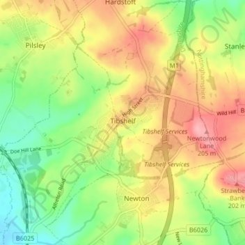
Name: Tibshelf topographic map, elevation, terrain.

Location: Tibshelf, Bolsover, Derbyshire, East Midlands, England, United Kingdom (53.12246 -1.37783 53.16260 -1.31884)

Average elevation: 152 m

Minimum elevation: 98 m

Maximum elevation: 210 m

Derbyshire trails, hiking, mountain biking, running and outdoor activities

Other topographic maps

Click on a map to view its topography, its elevation and its terrain.

Newton

United Kingdom > England > Derbyshire > Bolsover

Average elevation: 143 m

Pleasley Vale

United Kingdom > England > Derbyshire > Bolsover

Average elevation: 115 m

Langwith

United Kingdom > England > Derbyshire > Bolsover

Average elevation: 99 m

Hodthorpe

United Kingdom > England > Derbyshire > Bolsover

Average elevation: 78 m

New Houghton

United Kingdom > England > Derbyshire > Bolsover

Average elevation: 149 m

Hilcote

United Kingdom > England > Derbyshire > Bolsover

Average elevation: 141 m

Shuttlewood

United Kingdom > England > Derbyshire > Bolsover

Average elevation: 109 m

Upper Langwith

United Kingdom > England > Derbyshire > Bolsover

Average elevation: 112 m

Palterton

United Kingdom > England > Derbyshire > Bolsover

Average elevation: 133 m

Westhouses

United Kingdom > England > Derbyshire > Bolsover > Westhouses

Average elevation: 121 m

Gear up for your next adventure:

🎒Hiking Daypacks - Compact backpacks ideal for short hikes and excursions
Lightweight Solo Tents - Backpacking tents designed for wild camping in the UK highlands
🎒Hiking Daypacks (20L) - Compact backpacks for day trips and technical mountain ascents
🛰️Satellite Messengers - Emergency communication devices for areas without mobile signal
🐕Dog Hiking Gear - Equipment for hiking safely with dogs

As an Amazon Associate, this site earns from qualifying purchases at no extra cost to you.