
Make a donation
Gear up for your next adventure:
As an Amazon Associate, this site earns from qualifying purchases at no extra cost to you.
Lajatico topographic map
Click on the map to display elevation.
Make a donation
Gear up for your next adventure:
As an Amazon Associate, this site earns from qualifying purchases at no extra cost to you.
Lajatico
Lajatico is a comune (municipality) in the Province of Pisa in the Italian region Tuscany, located about 50 kilometers (31 mi) southwest of Florence and about 40 kilometers (25 mi) southeast of Pisa. Lajatico sits in mainly hilly terrain at variable elevations from 100 to 650 meters (330 to 2,130 ft) above sea level) and dominates both the end of the Valdera valley and the opening of the valley known as Val di Cecina.
Make a donation
Gear up for your next adventure:
As an Amazon Associate, this site earns from qualifying purchases at no extra cost to you.
About this map
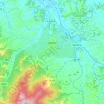
Name: Lajatico topographic map, elevation, terrain.
Location: Lajatico, Pisa, Tuscany, Italy (43.40992 10.65520 43.52070 10.79411)
Average elevation: 167 m
Minimum elevation: 46 m
Maximum elevation: 642 m
Make a donation
Gear up for your next adventure:
As an Amazon Associate, this site earns from qualifying purchases at no extra cost to you.