
Make a donation
Gear up for your next adventure:
As an Amazon Associate, this site earns from qualifying purchases at no extra cost to you.
Strathroy-Caradoc topographic map
Click on the map to display elevation.
Make a donation
Gear up for your next adventure:
As an Amazon Associate, this site earns from qualifying purchases at no extra cost to you.
Strathroy-Caradoc
The village came into existence as a result of the construction of the western division of the Great Western Railroad from London to Windsor, Ontario, at the point where it crossed the existing road from Delaware, Ontario to Strathroy. This crossing happened to be at the point of greatest elevation on this division, the railroad having just climbed out of the valley of the Thames River from London. The station was named for Charles John Brydges, the managing director of the Grand Trunk Railway from 1861 to 1874. The earlier name Carradoc was replaced in 1856.
Make a donation
Gear up for your next adventure:
As an Amazon Associate, this site earns from qualifying purchases at no extra cost to you.
About this map
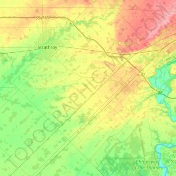
Name: Strathroy-Caradoc topographic map, elevation, terrain.
Location: Strathroy-Caradoc, Middlesex County, Ontario, Canada (42.80797 -81.68158 43.00495 -81.38760)
Average elevation: 236 m
Minimum elevation: 200 m
Maximum elevation: 284 m
Make a donation
Gear up for your next adventure:
As an Amazon Associate, this site earns from qualifying purchases at no extra cost to you.
Other topographic maps
Click on a map to view its topography, its elevation and its terrain.
Make a donation
Gear up for your next adventure:
As an Amazon Associate, this site earns from qualifying purchases at no extra cost to you.
Make a donation
Gear up for your next adventure:
As an Amazon Associate, this site earns from qualifying purchases at no extra cost to you.
Make a donation
Gear up for your next adventure:
As an Amazon Associate, this site earns from qualifying purchases at no extra cost to you.
Make a donation
Gear up for your next adventure:
As an Amazon Associate, this site earns from qualifying purchases at no extra cost to you.
Make a donation
Gear up for your next adventure:
As an Amazon Associate, this site earns from qualifying purchases at no extra cost to you.
Make a donation
Gear up for your next adventure:
As an Amazon Associate, this site earns from qualifying purchases at no extra cost to you.