Geolocate

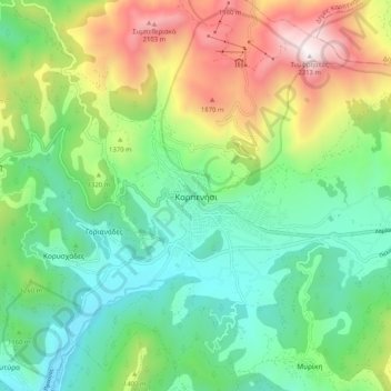
Karpenisi topographic map

Click on the map to display elevation.

Karpenisi

Karpenisi (Greek: Καρπενήσι, Greek pronunciation: [karpeˈnisi]) is a town in central Greece. It is the capital of the regional unit of Evrytania. Karpenisi lies within the valley of the river Karpenisiotis (Καρπενησιώτης), a tributary of the Megdovas, in the southern part of the Pindus Mountains. Mount Tymfristos (2,315 m elevation) lies directly to the north of the town, and the foothills of mount Kaliakouda are in the south. Karpenisi has a ski resort and is a popular destination, especially during winter.

Wikipedia (CC-BY-SA 3.0)

About this map

Name: Karpenisi topographic map, elevation, terrain.

Location: Karpenisi, Municipal Unit of Karpenisi, Karpenisi Municipality, Regional Unit of Evrytania, Central Greece, Thessaly and Central Greece, 361 00, Greece (38.87524 21.75435 38.95524 21.83435)

Average elevation: 1,236 m

Minimum elevation: 710 m

Maximum elevation: 2,301 m

Gear up for your next adventure:

🥾Women's Waterproof Hiking Boots - High-performance trekking boots designed for all-weather comfort
🛰️Outdoor GPS Navigation - Navigation devices for remote and off-grid areas
📍Handheld GPS Navigators - Reliable satellite navigation for hiking and off-road exploration
🧼Technical Clothing Wash - Special soap to clean and restore waterproof membranes
🔋Lithium AA Batteries - Long-lasting power that performs well in cold mountain weather

As an Amazon Associate, this site earns from qualifying purchases at no extra cost to you.