Geolocate

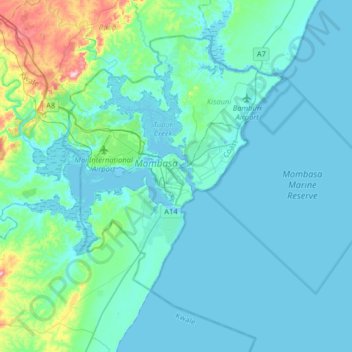
Mombasa topographic map

Click on the map to display elevation.

Mombasa

Being a coastal town, Mombasa is characterised by a flat topography. The town of Mombasa is centred on Mombasa Island, but extends to the mainland. The island is separated from the mainland by two creeks, Port Reitz in the south and Tudor Creek in the north.

Wikipedia (CC-BY-SA 3.0)

About this map

Name: Mombasa topographic map, elevation, terrain.

Location: Mombasa, Tononoka ward, Mvita, Mombasa County, 80100, Kenya (-4.21052 39.50717 -3.89052 39.82717)

Average elevation: 32 m

Minimum elevation: -3 m

Maximum elevation: 262 m

Other topographic maps

Click on a map to view its topography, its elevation and its terrain.

Tudor ward

Kenya > Mombasa County > Mvita > Tudor ward

Average elevation: 15 m

Ganjoni/Shimanzi ward

Kenya > Mombasa County > Mvita

Average elevation: 14 m

Gear up for your next adventure:

🚲Cycling GPS Computers - Track elevation and topographic routes on two wheels
📚UK Hiking Guidebooks - Detailed route descriptions for the Lake District, Peaks, and Highlands
🗺️Scratch-off Peak Maps - Track your progress climbing Munros or Wainwrights
📦Dry Bags - Waterproof bags to protect gear from rain
🦯Walking Poles - Supportive poles for long-distance walking

As an Amazon Associate, this site earns from qualifying purchases at no extra cost to you.