Geolocate

Milton topographic map

Click on the map to display elevation.

Milton

According to the U.S. Census Bureau, the city of Milton has a total area of 39.2 square miles (101.4 km2), of which 38.5 square miles (99.8 km2) is land and 0.62 square miles (1.6 km2), or 1.59%, is water. The elevation ranges from 950 to 1,280 feet (290 to 390 m) above sea level.

Wikipedia (CC-BY-SA 3.0)

About this map

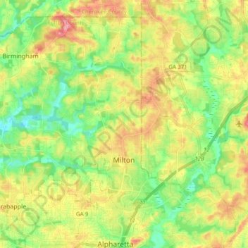
Name: Milton topographic map, elevation, terrain.

Location: Milton, Fulton County, Georgia, 30004, United States (34.07717 -84.39658 34.18629 -84.24473)

Average elevation: 330 m

Minimum elevation: 284 m

Maximum elevation: 393 m

Other topographic maps

Click on a map to view its topography, its elevation and its terrain.

Grant Park

United States > Georgia > Fulton County > Atlanta

Average elevation: 298 m

Simsville

United States > Georgia > Fulton County > Atlanta

Average elevation: 275 m

Blair Village

United States > Georgia > Fulton County > Atlanta

Average elevation: 275 m

Atlanta

United States > Georgia > Fulton County

Atlanta occupies a high, rolling part of the Georgia Piedmont, a physiographic region described as a landscape of low hills and narrow valleys between the Blue Ridge Mountains and the Upper Coastal Plain. Around downtown and Fulton County, the terrain is gently dissected rather than flat, with broad urban…

Average elevation: 285 m

Piedmont Park

United States > Georgia > Fulton County > Atlanta

Average elevation: 283 m

South Fulton

United States > Georgia > Fulton County

Average elevation: 272 m

Shake Rag

United States > Georgia > Fulton County > Johns Creek

Average elevation: 300 m

Central Park

United States > Georgia > Fulton County > Atlanta

Average elevation: 301 m

Shandra Estates

United States > Georgia > Fulton County

Average elevation: 289 m

Boulder Park

United States > Georgia > Fulton County > Atlanta

Average elevation: 257 m

Alpharetta

United States > Georgia > Fulton County > Alpharetta

Average elevation: 325 m

Gear up for your next adventure:

🖼️Topographic Map Art - Decorative 3D-effect posters of famous UK peaks and regions
📦Dry Bags - Waterproof bags to protect gear from rain
🧭Orienteering Compasses - Accurate compasses for map-based navigation
🧥Breathable Waterproof Jackets - Essential rain protection for the unpredictable British climate
🐕Hiking Dog Harnesses - Rugged harnesses for taking your companion on mountain trails

As an Amazon Associate, this site earns from qualifying purchases at no extra cost to you.