Geolocate

Prazeres topographic map

Click on the map to display elevation.

About this map
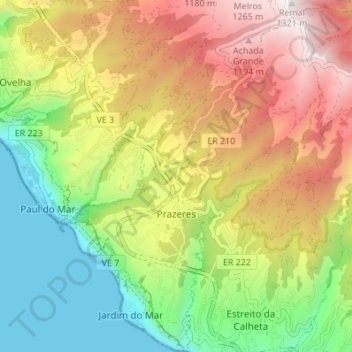
Name: Prazeres topographic map, elevation, terrain.

Location: Prazeres, Calheta, Madeira, Portugal (32.73146 -17.22119 32.78880 -17.16106)

Average elevation: 585 m

Minimum elevation: 0 m

Maximum elevation: 1,311 m

Other topographic maps

Click on a map to view its topography, its elevation and its terrain.

Lombo do Salão

Portugal > Calheta > Estrela

Average elevation: 347 m

Loreto

Portugal > Calheta > Arco da Calheta

Average elevation: 292 m

Raposeira

Portugal > Calheta > Fajã da Ovelha

Average elevation: 571 m

São Lourenço

Portugal > Calheta > Fajã da Ovelha

Average elevation: 413 m

Gear up for your next adventure:

🎒Hiking Child Carriers - Explore the outdoors with the whole family safely
🔪Outdoor Multi-Tools - Versatile tools for gear repairs and food prep in the wild
🎒Hiking Daypacks - Compact backpacks ideal for short hikes and excursions
🕶️Glacier Goggles - Maximum protection for high-altitude snow topography
📷Camera Straps - Secure straps for carrying cameras while walking

As an Amazon Associate, this site earns from qualifying purchases at no extra cost to you.