Geolocate

Möhnesee topographic map

Interactive map

Click on the map to display elevation.

About this map

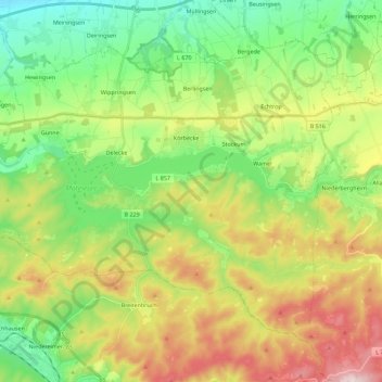
Name: Möhnesee topographic map, elevation, terrain.

Location: Möhnesee, Kreis Soest, North Rhine-Westphalia, 59519, Germany (51.42225 8.01131 51.53306 8.23657)

Average elevation: 265 m

Minimum elevation: 113 m

Maximum elevation: 514 m

Other topographic maps

Click on a map to view its topography, its elevation and its terrain.

Anröchte

Germany > North Rhine-Westphalia > Kreis Soest

Average elevation: 221 m

Körbecke

Germany > North Rhine-Westphalia > Kreis Soest

Average elevation: 249 m

Parsit

Germany > North Rhine-Westphalia > Kreis Soest > Parsit

Average elevation: 212 m

Lohne

Germany > North Rhine-Westphalia > Kreis Soest > Lohne

Average elevation: 110 m

Warstein

Germany > North Rhine-Westphalia > Kreis Soest

Warstein is located north of the Arnsberger Wald (forest) at a brook called Wäster. The area south of the city is mostly forested; the lightly forested Haarstrang mountain is to the north. The river Möhne flows between these two areas. The highest elevation is 581 m (1,906 ft) in the south of the city near a…

Average elevation: 373 m

Soest

Germany > North Rhine-Westphalia > Kreis Soest

Average elevation: 121 m