
Davenport topographic map
Interactive map
Click on the map to display elevation.
About this map
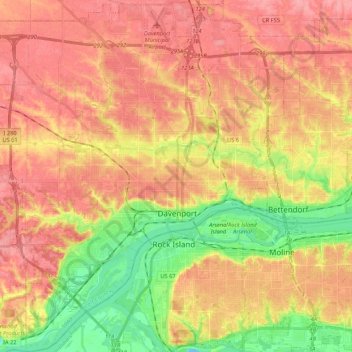
Name: Davenport topographic map, elevation, terrain.
Location: Davenport, Scott County, Iowa, United States (41.46063 -90.68793 41.62029 -90.49082)
Average elevation: 205 m
Minimum elevation: 157 m
Maximum elevation: 237 m
Other topographic maps
Click on a map to view its topography, its elevation and its terrain.
Park View
United States > Iowa > Scott County
Park View, Scott County, Iowa, United States
Average elevation: 235 m
Walcott
United States > Iowa > Scott County
Walcott, Blue Grass Township, Scott County, Iowa, United States
Average elevation: 227 m
Le Claire
United States > Iowa > Scott County
Le Claire, Le Claire Township, Scott County, Iowa, United States
Average elevation: 200 m
Davenport
United States > Iowa > Scott County > Davenport
Davenport, Scott County, Iowa, 52801, United States
Average elevation: 212 m