
Kos topographic map
Interactive map
Click on the map to display elevation.
About this map
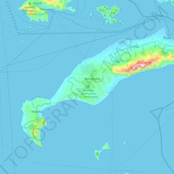
Name: Kos topographic map, elevation, terrain.
Location: Kos, Kos Regional Unit, South Aegean, Aegean, Greece (36.67169 26.91719 36.91567 27.35599)
Average elevation: 25 m
Minimum elevation: -5 m
Maximum elevation: 834 m
Other topographic maps
Click on a map to view its topography, its elevation and its terrain.
Kos
Greece > Aegean > Kos Regional Unit
Kos, Municipality of Kos, Kos Regional Unit, South Aegean, Aegean, 853 00, Greece
Average elevation: 32 m
Kastri
Greece > Aegean > Kos Regional Unit > Kefalos
Kastri, Kefalos, Municipality of Kos, Kos Regional Unit, South Aegean, Aegean, 853 01, Greece
Average elevation: 16 m
Kata beach
Greece > Aegean > Kos Regional Unit
Kata beach, Municipality of Kos, Kos Regional Unit, South Aegean, Aegean, Greece
Average elevation: 18 m
Nisyros
Greece > Aegean > Kos Regional Unit > Emborios
Nisyros, Emborios, Municipality of Nisyros, Kos Regional Unit, South Aegean, Aegean, 853 03, Greece
Average elevation: 126 m
Volcana beach
Greece > Aegean > Kos Regional Unit
Volcana beach, Municipality of Kos, Kos Regional Unit, South Aegean, Aegean, Greece
Average elevation: 13 m