
Gqeberha topographic map
Click on the map to display elevation.
About this map
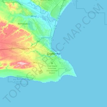
Name: Gqeberha topographic map, elevation, terrain.
Average elevation: 37 m
Minimum elevation: -2 m
Maximum elevation: 284 m
Other topographic maps
Click on a map to view its topography, its elevation and its terrain.
Baakens River
South Africa > Eastern Cape > Nelson Mandela Bay Metropolitan Municipality > Gqeberha
Average elevation: 108 m
Baakens River
South Africa > Eastern Cape > Nelson Mandela Bay Metropolitan Municipality > Gqeberha
Average elevation: 27 m
Swartkops River
South Africa > Eastern Cape > Nelson Mandela Bay Metropolitan Municipality > Redhouse
Average elevation: 26 m
Motherwell
South Africa > Eastern Cape > Nelson Mandela Bay Metropolitan Municipality
Average elevation: 67 m
Cape Recife
South Africa > Eastern Cape > Nelson Mandela Bay Metropolitan Municipality > Gqeberha > Noordhoek
Average elevation: 3 m
Former Bayworld Dolphinarium
South Africa > Eastern Cape > Nelson Mandela Bay Metropolitan Municipality > Gqeberha / Port Elizabeth
Average elevation: 18 m
Motherwell
South Africa > Eastern Cape > Nelson Mandela Bay Metropolitan Municipality
Average elevation: 67 m
KwaNobuhle
South Africa > Eastern Cape > Nelson Mandela Bay Metropolitan Municipality
Average elevation: 86 m
Despatch
South Africa > Eastern Cape > Nelson Mandela Bay Metropolitan Municipality
Average elevation: 66 m
Happy Valley
South Africa > Eastern Cape > Nelson Mandela Bay Metropolitan Municipality > Gqeberha
Average elevation: 20 m
Humewood Beach
South Africa > Eastern Cape > Nelson Mandela Bay Metropolitan Municipality > Gqeberha
Average elevation: 16 m
Baakens River
South Africa > Eastern Cape > Nelson Mandela Bay Metropolitan Municipality > Gqeberha
Average elevation: 108 m