
Thank you for supporting this site ❤️
Make a donation
Make a donation
Gear up for your next adventure:
As an Amazon Associate, this site earns from qualifying purchases at no extra cost to you.
Sainte-Rita topographic map
Click on the map to display elevation.
Thank you for supporting this site ❤️
Make a donation
Make a donation
Gear up for your next adventure:
As an Amazon Associate, this site earns from qualifying purchases at no extra cost to you.
About this map
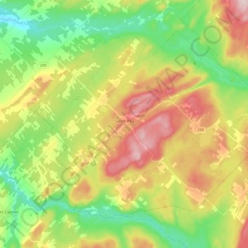
Name: Sainte-Rita topographic map, elevation, terrain.
Location: Sainte-Rita, Les Basques, Bas-Saint-Laurent, Quebec, Canada (47.89100 -68.99229 48.00480 -68.76966)
Average elevation: 275 m
Minimum elevation: 153 m
Maximum elevation: 443 m
Thank you for supporting this site ❤️
Make a donation
Make a donation
Gear up for your next adventure:
As an Amazon Associate, this site earns from qualifying purchases at no extra cost to you.
Other topographic maps
Click on a map to view its topography, its elevation and its terrain.
Rivière-Trois-Pistoles
Canada > Quebec > Les Basques > Notre-Dame-des-Neiges > Rivière-Trois-Pistoles
Average elevation: 50 m