
Make a donation
Gear up for your next adventure:
As an Amazon Associate, this site earns from qualifying purchases at no extra cost to you.
Ridgeville topographic map
Click on the map to display elevation.
Make a donation
Gear up for your next adventure:
As an Amazon Associate, this site earns from qualifying purchases at no extra cost to you.
About this map
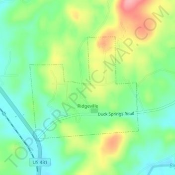
Name: Ridgeville topographic map, elevation, terrain.
Location: Ridgeville, Etowah County, Alabama, United States (34.05060 -86.11302 34.06631 -86.09278)
Average elevation: 209 m
Minimum elevation: 164 m
Maximum elevation: 284 m
Make a donation
Gear up for your next adventure:
As an Amazon Associate, this site earns from qualifying purchases at no extra cost to you.
Other topographic maps
Click on a map to view its topography, its elevation and its terrain.
Make a donation
Gear up for your next adventure:
As an Amazon Associate, this site earns from qualifying purchases at no extra cost to you.
Rainbow City
United States > Alabama > Etowah County > Rainbow City > Rainbow City
Average elevation: 178 m
Make a donation
Gear up for your next adventure:
As an Amazon Associate, this site earns from qualifying purchases at no extra cost to you.