
Kobroor topographic map
Interactive map
Click on the map to display elevation.
About this map
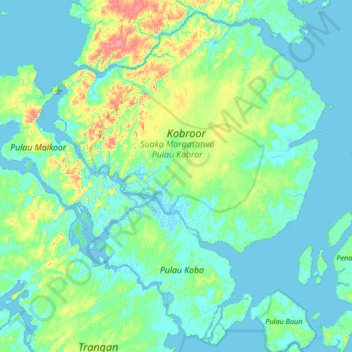
Name: Kobroor topographic map, elevation, terrain.
Location: Kobroor, Aru Islands, Moluccas, Indonesia (-6.37400 134.27094 -5.91873 134.78216)
Average elevation: 16 m
Minimum elevation: -4 m
Maximum elevation: 79 m
Other topographic maps
Click on a map to view its topography, its elevation and its terrain.
Pulau Warilau
Indonesia > Moluccas > Aru Islands > Waria
Pulau Warilau, Waria, Aru Islands, Moluccas, Maluku, Indonesia
Average elevation: 5 m
Sewer
Indonesia > Moluccas > Aru Islands
Sewer, Aru Islands, Moluccas, Maluku, Indonesia
Average elevation: 14 m