
Trenčín topographic map
Interactive map
Click on the map to display elevation.
Trenčín
Trenčín lies at an altitude of 262 metres (860 ft) above sea level and covers an area of 82 square kilometres (31.7 sq mi). It lies in the Trenčín Basin of north-western Slovakia, which is surrounded by the Strážov Mountains, Považský Inovec and White Carpathians, with the last mentioned being a protected area. The Váh River flows in the north–south axis.
About this map
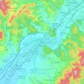
Name: Trenčín topographic map, elevation, terrain.
Average elevation: 307 m
Minimum elevation: 191 m
Maximum elevation: 756 m
Other topographic maps
Click on a map to view its topography, its elevation and its terrain.
Veľká Javorina
Slovakia > Region of Trenčín > District of Nové Mesto nad Váhom
The massif of Velká Javořina is located in the southwest part of the White Carpathians and is built of flysch rocks with significant thickness, in which layers of sandstone (dating from the Upper Cretaceous to the Lower Paleocene) and fine-grained marine sediments (shales and marls) rhythmically repeat. The…
Average elevation: 774 m