
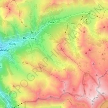
Barèges topographic map
Interactive map
Click on the map to display elevation.
About this map
Name: Barèges topographic map, elevation, terrain.
Average elevation: 1,844 m
Minimum elevation: 721 m
Maximum elevation: 3,070 m
The town is bounded in the north-west by the Bastan river which flows from east to west in a narrow valley through the main village (at an altitude of 1250 m) and through its main inhabited areas. The Bastan forms the northern border of the commune with the commune of Sers.
Other topographic maps
Click on a map to view its topography, its elevation and its terrain.
Lac de Gaube
France > Occitania > Hautes Pyrenees > Cauterets
Lac de Gaube, Cauterets, Argelès-Gazost, Hautes Pyrenees, Occitania, Metropolitan France, 65110, France
Average elevation: 2,079 m
Gavarnie-Gèdre
France > Occitania > Hautes Pyrenees
Gavarnie-Gèdre, Argelès-Gazost, Hautes Pyrenees, Occitania, Metropolitan France, 65120, France
Average elevation: 2,115 m
Marsac
France > Occitania > Hautes Pyrenees
Marsac, Tarbes, Hautes Pyrenees, Occitania, Metropolitan France, 65500, France
Average elevation: 247 m
Payolle
France > Occitania > Hautes Pyrenees > Campan
Payolle, Campan, Bagnères-de-Bigorre, Hautes Pyrenees, Occitania, Metropolitan France, 65710, France
Average elevation: 1,281 m
Hèches
France > Occitania > Hautes Pyrenees
Hèches, Bagnères-de-Bigorre, Hautes Pyrenees, Occitania, Metropolitan France, 65250, France
Average elevation: 945 m
Maubourguet
France > Occitania > Hautes Pyrenees
Maubourguet, Tarbes, Hautes Pyrenees, Occitania, Metropolitan France, 65700, France
Average elevation: 186 m
Vue sur Cascades et Pont d'Espagne
France > Occitania > Hautes Pyrenees > Cauterets
Vue sur Cascades et Pont d'Espagne, Pont d'Espagne, Cauterets, Argelès-Gazost, Hautes Pyrenees, Occitania, Metropolitan France, 65110, France
Average elevation: 1,827 m
Pic du lac noir
France > Occitania > Hautes Pyrenees > Luz-Saint-Sauveur
Pic du lac noir, Luz-Saint-Sauveur, Argelès-Gazost, Hautes Pyrenees, Occitania, Metropolitan France, 65120, France
Average elevation: 2,440 m
Trébons
France > Occitania > Hautes Pyrenees
Trébons, Bagnères-de-Bigorre, Hautes Pyrenees, Occitania, Metropolitan France, 65200, France
Average elevation: 549 m
Sers
France > Occitania > Hautes Pyrenees
Sers, Argelès-Gazost, Hautes Pyrenees, Occitania, Metropolitan France, 65120, France
Average elevation: 1,668 m
Monléon-Magnoac
France > Occitania > Hautes Pyrenees
Monléon-Magnoac, Tarbes, Hautes Pyrenees, Occitania, Metropolitan France, 65670, France
Average elevation: 403 m
Sarp
France > Occitania > Hautes Pyrenees
Sarp, Bagnères-de-Bigorre, Hautes Pyrenees, Occitania, Metropolitan France, 65370, France
Average elevation: 498 m
Vignec
France > Occitania > Hautes Pyrenees
Vignec, Bagnères-de-Bigorre, Hautes Pyrenees, Occitania, Metropolitan France, 65170, France
Average elevation: 1,232 m
Vic-en-Bigorre
France > Occitania > Hautes Pyrenees
Vic-en-Bigorre, Tarbes, Hautes Pyrenees, Occitania, Metropolitan France, 65500, France
Average elevation: 225 m
Arcizans-Dessus
France > Occitania > Hautes Pyrenees
Arcizans-Dessus, Argelès-Gazost, Hautes Pyrenees, Occitania, Metropolitan France, 65400, France
Average elevation: 1,036 m
Gèdre
France > Occitania > Hautes Pyrenees > Gavarnie-Gèdre
Gèdre, Gavarnie-Gèdre, Argelès-Gazost, Hautes Pyrenees, Occitania, Metropolitan France, 65120, France
Average elevation: 2,136 m
Bettes
France > Occitania > Hautes Pyrenees
Bettes, Bagnères-de-Bigorre, Hautes Pyrenees, Occitania, Metropolitan France, 65130, France
Average elevation: 541 m
Castelnau-Magnoac
France > Occitania > Hautes Pyrenees
Castelnau-Magnoac, Tarbes, Hautes Pyrenees, Occitania, Metropolitan France, 65230, France
Average elevation: 307 m
Ségus
France > Occitania > Hautes Pyrenees
Ségus, Argelès-Gazost, Hautes Pyrenees, Occitania, Metropolitan France, 65100, France
Average elevation: 687 m
Dours
France > Occitania > Hautes Pyrenees
Dours, Tarbes, Hautes Pyrenees, Occitania, Metropolitan France, 65350, France
Average elevation: 275 m
Loures-Barousse
France > Occitania > Hautes Pyrenees
Loures-Barousse, Bagnères-de-Bigorre, Hautes Pyrenees, Occitania, Metropolitan France, 65370, France
Average elevation: 455 m
Trie-sur-Baïse
France > Occitania > Hautes Pyrenees > Trie-sur-Baïse
Trie-sur-Baïse, Tarbes, Hautes Pyrenees, Occitania, Metropolitan France, 65220, France
Average elevation: 282 m
Aragnouet
France > Occitania > Hautes Pyrenees
Aragnouet, Bagnères-de-Bigorre, Hautes Pyrenees, Occitania, Metropolitan France, 65170, France
Average elevation: 2,055 m
Nistos
France > Occitania > Hautes Pyrenees > Nistos
Nistos, Bagnères-de-Bigorre, Hautes Pyrenees, Occitania, Metropolitan France, 65150, France
Average elevation: 1,004 m
Germ
France > Occitania > Hautes Pyrenees
Germ, Bagnères-de-Bigorre, Hautes Pyrenees, Occitania, Metropolitan France, 65240, France
Average elevation: 1,677 m
Cirque de Gavarnie
France > Occitania > Hautes Pyrenees > Gavarnie-Gèdre > Gavarnie
Cirque de Gavarnie, Gavarnie, Gavarnie-Gèdre, Argelès-Gazost, Hautes Pyrenees, Occitania, Metropolitan France, 65120, France
Average elevation: 2,364 m
Gavarnie
France > Occitania > Hautes Pyrenees > Gavarnie-Gèdre
Gavarnie, Gavarnie-Gèdre, Argelès-Gazost, Hautes Pyrenees, Occitania, Metropolitan France, 65120, France
Average elevation: 2,119 m
Marseillan
France > Occitania > Hautes Pyrenees
Marseillan, Tarbes, Hautes Pyrenees, Occitania, Metropolitan France, 65350, France
Average elevation: 242 m
Viger
France > Occitania > Hautes Pyrenees > Viger
Viger, Argelès-Gazost, Hautes Pyrenees, Occitania, Metropolitan France, 65100, France
Average elevation: 543 m
Uzer
France > Occitania > Hautes Pyrenees > Uzer
Uzer, Bagnères-de-Bigorre, Hautes Pyrenees, Occitania, Metropolitan France, 65200, France
Average elevation: 561 m
Vallée du Marcadau
France > Occitania > Hautes Pyrenees > Cauterets
Vallée du Marcadau, Cauterets, Argelès-Gazost, Hautes Pyrenees, Occitania, Metropolitan France, 65110, France
Average elevation: 1,993 m
Pierrefitte-Nestalas
France > Occitania > Hautes Pyrenees > Pierrefitte-Nestalas > Pierrefitte-Nestalas
Pierrefitte-Nestalas, Argelès-Gazost, Hautes Pyrenees, Occitania, Metropolitan France, 65260, France
Average elevation: 712 m
Ris
France > Occitania > Hautes Pyrenees > Ris
Ris, Bagnères-de-Bigorre, Hautes Pyrenees, Occitania, Metropolitan France, 65590, France
Average elevation: 1,093 m
Arné
France > Occitania > Hautes Pyrenees > Arné
Arné, Bagnères-de-Bigorre, Hautes Pyrenees, Occitania, Metropolitan France, 65670, France
Average elevation: 491 m
Salles
France > Occitania > Hautes Pyrenees
Salles, Argelès-Gazost, Hautes Pyrenees, Occitania, Metropolitan France, 65400, France
Average elevation: 859 m
Lagarde
France > Occitania > Hautes Pyrenees > Lagarde
Lagarde, Tarbes, Hautes Pyrenees, Occitania, Metropolitan France, 65320, France
Average elevation: 281 m
Barry
France > Occitania > Hautes Pyrenees
Barry, Tarbes, Hautes Pyrenees, Occitania, Metropolitan France, 65380, France
Average elevation: 431 m
Lourdes
France > Occitania > Hautes Pyrenees
Lourdes, Argelès-Gazost, Hautes Pyrenees, Occitania, Metropolitan France, 65100, France
Average elevation: 514 m
Loudenvielle
France > Occitania > Hautes Pyrenees > Loudenvielle
Loudenvielle, Bagnères-de-Bigorre, Hautes Pyrenees, Occitania, Metropolitan France, 65510, France
Average elevation: 1,974 m
Estaing
France > Occitania > Hautes Pyrenees
Estaing, Argelès-Gazost, Hautes Pyrenees, Occitania, Metropolitan France, 65400, France
Average elevation: 1,782 m
Tarbes
France > Occitania > Hautes Pyrenees
Tarbes, Hautes Pyrenees, Occitania, Metropolitan France, 65000, France
Average elevation: 308 m
Eget Village
France > Occitania > Hautes Pyrenees > Aragnouet > Eget Village
Eget Village, Aragnouet, Bagnères-de-Bigorre, Hautes Pyrenees, Occitania, Metropolitan France, 65170, France
Average elevation: 1,560 m
Sost
France > Occitania > Hautes Pyrenees
Sost, Bagnères-de-Bigorre, Hautes Pyrenees, Occitania, Metropolitan France, 65370, France
Average elevation: 1,284 m
Cauterets
France > Occitania > Hautes Pyrenees
Cauterets, Argelès-Gazost, Hautes Pyrenees, Occitania, Metropolitan France, 65110, France
Average elevation: 1,817 m
Juillan
France > Occitania > Hautes Pyrenees
Juillan, Tarbes, Hautes Pyrenees, Occitania, Metropolitan France, 65290, France
Average elevation: 338 m
Pic du Midi de Bigorre
France > Occitania > Hautes Pyrenees > Bagnères-de-Bigorre
Pic du Midi de Bigorre, Bagnères-de-Bigorre, Hautes Pyrenees, Occitania, Metropolitan France, France
Average elevation: 2,280 m
Viella
France > Occitania > Hautes Pyrenees > Viella
Viella, Argelès-Gazost, Hautes Pyrenees, Occitania, Metropolitan France, 65120, France
Average elevation: 1,109 m
Samuran
France > Occitania > Hautes Pyrenees
Samuran, Bagnères-de-Bigorre, Hautes Pyrenees, Occitania, Metropolitan France, 65370, France
Average elevation: 713 m
Esterre
France > Occitania > Hautes Pyrenees
Esterre, Argelès-Gazost, Hautes Pyrenees, Occitania, Metropolitan France, 65120, France
Average elevation: 965 m