Geolocate

Surallah topographic map

Click on the map to display elevation.

About this map

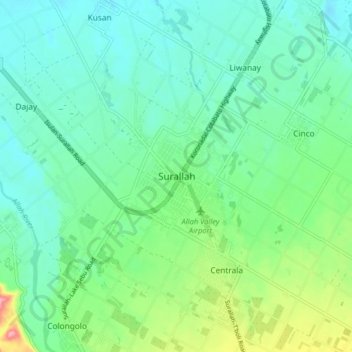
Name: Surallah topographic map, elevation, terrain.

Location: Surallah, South Cotabato, Soccsksargen, 9512, Philippines (6.33561 124.70725 6.41561 124.78725)

Average elevation: 188 m

Minimum elevation: 154 m

Maximum elevation: 291 m

Other topographic maps

Click on a map to view its topography, its elevation and its terrain.

Lake Holon

Philippines > South Cotabato > T'Boli

Average elevation: 1,452 m

Polomolok

Philippines > South Cotabato

Average elevation: 485 m

Caloocan

Philippines > South Cotabato > Koronadal

Average elevation: 42 m

Koronadal

Philippines > South Cotabato

Average elevation: 164 m

Gear up for your next adventure:

📸Action Camera Chest Mounts - Record your ascent following topographic paths hands-free
🌄Outdoor Binoculars - Compact binoculars for landscape observation
🛌Sleeping Bags - Warm and packable sleeping bags for outdoor nights
🎿Telescopic Trekking Poles - Reduces knee strain on steep topographic descents
🧺Microfibre Travel Towels - Fast-drying and compact towels for wild swimming and camping

As an Amazon Associate, this site earns from qualifying purchases at no extra cost to you.