Geolocate

Weida topographic map

Click on the map to display elevation.

About this map
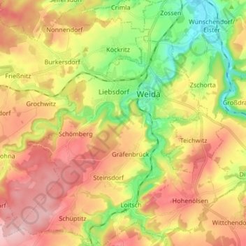
Name: Weida topographic map, elevation, terrain.

Location: Weida, Greiz, Thuringia, 07570, Germany (50.72161 11.98999 50.80583 12.11254)

Average elevation: 315 m

Minimum elevation: 206 m

Maximum elevation: 423 m

Other topographic maps

Click on a map to view its topography, its elevation and its terrain.

Eichleite

Germany > Thuringia > Greiz > Greiz > Caselwitz

Average elevation: 345 m

Zeulenroda

Germany > Thuringia > Greiz

Average elevation: 406 m

Pansdorf

Germany > Thuringia > Greiz

Average elevation: 402 m

Bernsgrün

Germany > Thuringia > Greiz

Average elevation: 483 m

Zadelsdorf

Germany > Thuringia > Greiz

Average elevation: 387 m

Frießnitz

Germany > Thuringia > Greiz

Average elevation: 328 m

Gear up for your next adventure:

📚UK Hiking Guidebooks - Detailed route descriptions for the Lake District, Peaks, and Highlands
🧥Waterproof Hiking Jackets - Rain protection for walking in all weather conditions
👟Men's Trail Running Shoes - Lightweight grip for fast movement over topographic contours
🥾Hiking Boot Waterproofing Wax - Maintain the lifespan of your leather trekking boots
👕Technical Hiking Tees - Moisture-management for high-exertion climbs

As an Amazon Associate, this site earns from qualifying purchases at no extra cost to you.