
Cranage topographic map
Interactive map
Click on the map to display elevation.
About this map
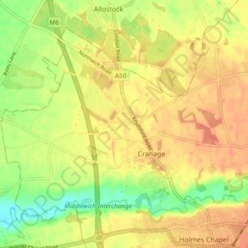
Name: Cranage topographic map, elevation, terrain.
Location: Cranage, Cheshire East, England, United Kingdom (53.20327 -2.41418 53.23435 -2.34719)
Average elevation: 52 m
Minimum elevation: 27 m
Maximum elevation: 68 m
Other topographic maps
Click on a map to view its topography, its elevation and its terrain.
Buerton
United Kingdom > England > Cheshire East
Buerton, Cheshire East, England, United Kingdom
Average elevation: 97 m
Toft
United Kingdom > England > Cheshire East
Toft, Cheshire East, England, United Kingdom
Average elevation: 57 m
Winterley
United Kingdom > England > Cheshire East
Winterley, Cheshire East, England, CW11 4RS, United Kingdom
Average elevation: 62 m
Wood Lanes
United Kingdom > England > Cheshire East > Poynton
Wood Lanes, Adlington, Poynton, Cheshire East, England, SK10 4PE, United Kingdom
Average elevation: 162 m
Dean Row
United Kingdom > England > Cheshire East > Wilmslow
Dean Row, Wilmslow, Cheshire East, England, SK9 2BN, United Kingdom
Average elevation: 83 m
Arclid
United Kingdom > England > Cheshire East
Arclid, Cheshire East, England, United Kingdom
Average elevation: 75 m
Lyme Park
United Kingdom > England > Cheshire East > Disley
Lyme Park, Disley, Cheshire East, England, United Kingdom
Average elevation: 260 m
Peckforton Moss
United Kingdom > England > Cheshire East > Bulkeley > Peckforton
Peckforton Moss, Peckforton, Bulkeley, Cheshire East, England, United Kingdom
Average elevation: 100 m
Cholmondeley
United Kingdom > England > Cheshire East
Cholmondeley, Cheshire East, England, United Kingdom
Average elevation: 94 m
Oakgrove
United Kingdom > England > Cheshire East
Oakgrove, Cheshire East, England, SK11 0JF, United Kingdom
Average elevation: 200 m
Peover Heath
United Kingdom > England > Cheshire East > Over Peover
Peover Heath, Peover Superior and Snelson, Over Peover, Cheshire East, England, WA16 8UP, United Kingdom
Average elevation: 73 m
Crewe Green
United Kingdom > England > Cheshire East
Crewe Green, Cheshire East, England, CW1 5UN, United Kingdom
Average elevation: 58 m
Macclesfield
United Kingdom > England > Cheshire East
Macclesfield, Cheshire East, England, United Kingdom
Average elevation: 182 m
Poynton
United Kingdom > England > Cheshire East
Poynton, Cheshire East, England, SK12 1GP, United Kingdom
Average elevation: 130 m
Marbury
United Kingdom > England > Cheshire East
Marbury, Cheshire East, England, SY13 4LS, United Kingdom
Average elevation: 92 m
Broomhall
United Kingdom > England > Cheshire East
Broomhall, Cheshire East, England, United Kingdom
Average elevation: 60 m
Capesthorne
United Kingdom > England > Cheshire East > Siddington
Capesthorne, Siddington, Cheshire East, England, SK11 9LB, United Kingdom
Average elevation: 93 m
Wilmslow
United Kingdom > England > Cheshire East
Wilmslow, Cheshire East, England, SK9 1DS, United Kingdom
Average elevation: 84 m
Checkley
United Kingdom > England > Cheshire East
Checkley, Checkley cum Wrinehill, Cheshire East, England, CW5 7QA, United Kingdom
Average elevation: 85 m
Chelford
United Kingdom > England > Cheshire East
Chelford, Cheshire East, England, United Kingdom
Average elevation: 78 m
Scholar Green
United Kingdom > England > Cheshire East
Scholar Green, Cheshire East, England, ST7 3HH, United Kingdom
Average elevation: 124 m
Crewe
United Kingdom > England > Cheshire East
Crewe, Cheshire East, England, United Kingdom
Average elevation: 52 m
Macclesfield Canal
United Kingdom > England > Cheshire East > Stockport
Macclesfield Canal, Stockport, Cheshire East, Greater Manchester, England, SK10 4GX, United Kingdom
Average elevation: 191 m
Calveley
United Kingdom > England > Cheshire East
Calveley, Cheshire East, England, United Kingdom
Average elevation: 51 m
Haslington
United Kingdom > England > Cheshire East
Haslington, Cheshire East, England, United Kingdom
Average elevation: 64 m
Disley
United Kingdom > England > Cheshire East
Disley, Cheshire East, England, United Kingdom
Average elevation: 229 m
Nantwich
United Kingdom > England > Cheshire East
Nantwich, Cheshire East, England, United Kingdom
Average elevation: 45 m
Ridgegate Reservoir
United Kingdom > England > Cheshire East > Langley
Ridgegate Reservoir, Sutton, Langley, Cheshire East, England, United Kingdom
Average elevation: 289 m
Styal
United Kingdom > England > Cheshire East
Styal, Cheshire East, England, United Kingdom
Average elevation: 76 m
Higher Poynton
United Kingdom > England > Cheshire East > Poynton > Higher Poynton
Higher Poynton, Poynton-with-Worth, Poynton, Cheshire East, England, SK12 1TJ, United Kingdom
Average elevation: 157 m
Somerford
United Kingdom > England > Cheshire East
Somerford, Cheshire East, England, United Kingdom
Average elevation: 82 m
Hulme Walfield
United Kingdom > England > Cheshire East > Hulme Walfield
Hulme Walfield, Cheshire East, England, United Kingdom
Average elevation: 99 m
Wilmslow
United Kingdom > England > Cheshire East
Wilmslow, Cheshire East, England, United Kingdom
Average elevation: 81 m
Bickerton
United Kingdom > England > Cheshire East
Bickerton, Cheshire East, England, United Kingdom
Average elevation: 128 m
Kettleshulme
United Kingdom > England > Cheshire East > Kettleshulme
Kettleshulme, Cheshire East, North West England, England, United Kingdom
Average elevation: 311 m
Walgherton
United Kingdom > England > Cheshire East > Wybunbury > Walgherton
Walgherton, Wybunbury, Cheshire East, North West England, England, United Kingdom
Average elevation: 63 m
Chorley
United Kingdom > England > Cheshire East > Chorley
Chorley, Cheshire East, North West England, England, United Kingdom
Average elevation: 73 m
Burleydam
United Kingdom > England > Cheshire East > Burleydam
Burleydam, Dodcott cum Wilkesley, Cheshire East, North West England, England, SY13 4AT, United Kingdom
Average elevation: 79 m
Knutsford
United Kingdom > England > Cheshire East
Knutsford, Cheshire East, England, United Kingdom
Average elevation: 57 m
Weston
United Kingdom > England > Cheshire East
Weston, Cheshire East, North West England, England, United Kingdom
Average elevation: 69 m
Ollerton
United Kingdom > England > Cheshire East
Ollerton, Cheshire East, England, United Kingdom
Average elevation: 66 m
Gawsworth
United Kingdom > England > Cheshire East
Gawsworth, Cheshire East, North West England, England, United Kingdom
Average elevation: 145 m
Goostrey
United Kingdom > England > Cheshire East
Goostrey, Cheshire East, England, United Kingdom
Average elevation: 67 m
Tabley
United Kingdom > England > Cheshire East > Over Tabley > Tabley
Tabley, Tabley Superior, Over Tabley, Cheshire East, North West England, England, WA16 0WN, United Kingdom
Average elevation: 51 m
Wistaston
United Kingdom > England > Cheshire East
Wistaston, Cheshire East, North West England, England, United Kingdom
Average elevation: 46 m
Alderley Edge
United Kingdom > England > Cheshire East
Alderley Edge, Cheshire East, England, United Kingdom
Average elevation: 91 m
Sandbach
United Kingdom > England > Cheshire East
Sandbach, Cheshire East, England, United Kingdom
Average elevation: 64 m
Over Alderley
United Kingdom > England > Cheshire East
Over Alderley, Cheshire East, North West England, England, United Kingdom
Average elevation: 142 m
Whirley Grove
United Kingdom > England > Cheshire East > Macclesfield > Whirley Grove
Whirley Grove, Macclesfield, Cheshire East, North West England, England, SK10 4RJ, United Kingdom
Average elevation: 154 m
Bosley
United Kingdom > England > Cheshire East
Bosley, Cheshire East, North West England, England, United Kingdom
Average elevation: 208 m