Geolocate

Tangail topographic map

Click on the map to display elevation.

Tangail

Tangail was a popular local business centre since the early 19th century. But the name came on focus when the headquarter of a subdivision of the Greater Mymensingh District was shifted in 1860 from Atia to there due to its fertility and high elevation near Louhajong River. At the same time, The subdivision was named as Tangail.

Wikipedia (CC-BY-SA 3.0)

About this map

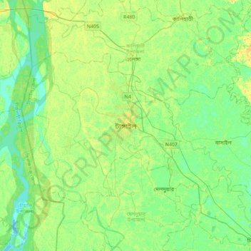
Name: Tangail topographic map, elevation, terrain.

Location: Tangail, Tangail Sadar Upazila, Tangail District, Dhaka Division, 1900, Bangladesh (24.09075 89.75515 24.41075 90.07515)

Average elevation: 11 m

Minimum elevation: 2 m

Maximum elevation: 24 m

Gear up for your next adventure:

🧷Tenacious Repair Tape - Instant fix for torn tents, jackets, or dry bags
🧥Packable Down Jackets - Lightweight warmth that compresses small in your bag
📻Hand-Crank Emergency Radios - Stay updated on weather warnings in remote areas
❄️Walking Crampons - Added traction for icy slopes and winter peak bagging
🗺️Scratch-off Peak Maps - Track your progress climbing Munros or Wainwrights

As an Amazon Associate, this site earns from qualifying purchases at no extra cost to you.