
Chavara topographic map
Interactive map
Click on the map to display elevation.
About this map
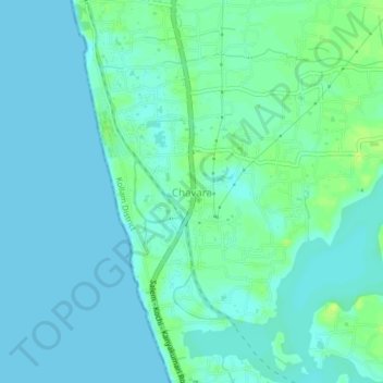
Name: Chavara topographic map, elevation, terrain.
Location: Chavara, Karunagappally, Kollam District, Kerala, 698582, India (8.95540 76.51484 8.99540 76.55484)
Average elevation: 4 m
Minimum elevation: 0 m
Maximum elevation: 14 m
Other topographic maps
Click on a map to view its topography, its elevation and its terrain.
Thevalakkara
India > Kerala > Karunagappally > Kovoor
Thevalakkara, Kovoor, Karunagappally, Kollam, Kerala, India
Average elevation: 10 m
Neendakara
India > Kerala > Karunagappally
Neendakara, Karunagappally, Kollam, Kerala, 691582, India
Average elevation: 3 m
Thazhava
India > Kerala > Karunagappally > Thazhava
Thazhava, Karunagappally, Kollam, Kerala, 69523, India
Average elevation: 13 m
small channal from NW3
India > Kerala > Karunagappally > Chavara
small channal from NW3, Chavara, Karunagappally, Kollam, Kerala, 698582, India
Average elevation: 3 m