
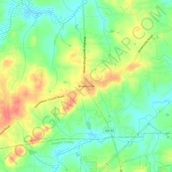
Brownsville topographic map
Interactive map
Click on the map to display elevation.
About this map
Name: Brownsville topographic map, elevation, terrain.
Location: Brownsville, Paulding County, Georgia, 30134, United States (33.77955 -84.77744 33.81955 -84.73744)
Average elevation: 299 m
Minimum elevation: 274 m
Maximum elevation: 332 m
Other topographic maps
Click on a map to view its topography, its elevation and its terrain.
Dallas
United States > Georgia > Paulding County
Dallas, Paulding County, Georgia, United States
Average elevation: 307 m
Nebo
United States > Georgia > Paulding County > Hiram
Nebo, Hiram, Paulding County, Georgia, 30140, United States
Average elevation: 317 m