
Lenzerheide topographic map
Interactive map
Click on the map to display elevation.
About this map
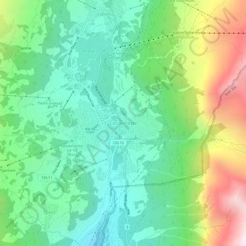
Name: Lenzerheide topographic map, elevation, terrain.
Location: Lenzerheide, Vaz/Obervaz, Albula, Grisons, 7078, Switzerland (46.70803 9.53844 46.74803 9.57844)
Average elevation: 1,723 m
Minimum elevation: 1,323 m
Maximum elevation: 2,582 m
Other topographic maps
Click on a map to view its topography, its elevation and its terrain.
Valbella
Switzerland > Grisons > Albula > Vaz/Obervaz > Valbella
Valbella, Vaz/Obervaz, Albula, Grisons, 7077, Switzerland
Average elevation: 1,720 m