
Make a donation
Gear up for your next adventure:
As an Amazon Associate, this site earns from qualifying purchases at no extra cost to you.
Kecamatan Pujut topographic map
Click on the map to display elevation.
Make a donation
Gear up for your next adventure:
As an Amazon Associate, this site earns from qualifying purchases at no extra cost to you.
About this map
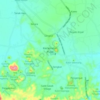
Name: Kecamatan Pujut topographic map, elevation, terrain.
Average elevation: 113 m
Minimum elevation: 74 m
Maximum elevation: 267 m
Make a donation
Gear up for your next adventure:
As an Amazon Associate, this site earns from qualifying purchases at no extra cost to you.
Other topographic maps
Click on a map to view its topography, its elevation and its terrain.
Sungai Pandan
Indonesia > West Nusa Tenggara > Lombok Tengah > Kecamatan Praya Barat Daya
Average elevation: 73 m
REBAN BISOK BOKAH
Indonesia > West Nusa Tenggara > Lombok Tengah > Batas Desa Bebuak > Dusun Apit Aik
Average elevation: 400 m
Batas Dusn montong Bulok
Indonesia > West Nusa Tenggara > Lombok Tengah > BATAS DESA MONTONG GAMANG
Average elevation: 342 m
Make a donation
Gear up for your next adventure:
As an Amazon Associate, this site earns from qualifying purchases at no extra cost to you.