
Make a donation
Gear up for your next adventure:
As an Amazon Associate, this site earns from qualifying purchases at no extra cost to you.
Santurtzi topographic map
Click on the map to display elevation.
Make a donation
Gear up for your next adventure:
As an Amazon Associate, this site earns from qualifying purchases at no extra cost to you.
Santurtzi
Santurtzi has a very rough orography although excluding Mount Serantes (452m) - one of its most symbolic topographic elements, it is not at high altitude, the significant heights being spurs of the Serantes (Serandi): The Mallet (245m) and the Fortified heights (123 and 106m). Its relief is within the north flank of the anticline of Biscay. It is a relief of a structural type corresponding to a series of materials of the Cretaceous period (limestone) throughout Punta Lucero-Serantes smoothly inclined towards the Estuary of Bilbao.
Make a donation
Gear up for your next adventure:
As an Amazon Associate, this site earns from qualifying purchases at no extra cost to you.
About this map
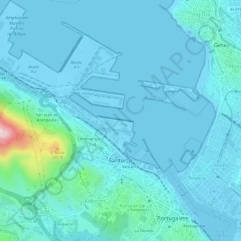
Name: Santurtzi topographic map, elevation, terrain.
Average elevation: 34 m
Minimum elevation: -3 m
Maximum elevation: 360 m
Make a donation
Gear up for your next adventure:
As an Amazon Associate, this site earns from qualifying purchases at no extra cost to you.