
Copperopolis topographic map
Click on the map to display elevation.
About this map
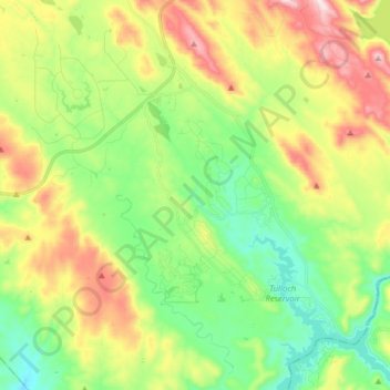
Name: Copperopolis topographic map, elevation, terrain.
Average elevation: 304 m
Minimum elevation: 126 m
Maximum elevation: 602 m
Other topographic maps
Click on a map to view its topography, its elevation and its terrain.
Angels
United States > California > Calaveras County
Angels Camp, also known as City of Angels and formerly Angel's Camp, Angels, Angels City, Carson's Creek and Clearlake, is the only incorporated city in Calaveras County, California, United States. The population was 3,836 at the 2010 census, up from 3,004 at the 2000 census. It lies at an elevation of 1378…
Average elevation: 459 m
Murphys
United States > California > Calaveras County
"MURPHY'S CAMP is a curious old mining-town in Calaveras County, at an elevation of 2,400 feet (730 m) above the sea, situated like a nest in the center of a rough, gravelly region, rich in gold. Granites, slates, lavas, limestone, iron ores, quartz veins, auriferous gravels, remnants of dead fire-rivers and…
Average elevation: 702 m
Murphys
United States > California > Calaveras County > Murphys
"MURPHY'S CAMP is a curious old mining-town in Calaveras County, at an elevation of 2,400 feet (730 m) above the sea, situated like a nest in the center of a rough, gravelly region, rich in gold. Granites, slates, lavas, limestone, iron ores, quartz veins, auriferous gravels, remnants of dead fire-rivers and…
Average elevation: 717 m
Angels Camp
United States > California > Calaveras County
Angels Camp, also known as City of Angels and formerly Angel's Camp, Angels, Angels City, Carson's Creek and Clearlake, is the only incorporated city in Calaveras County, California, United States. The population was 3,836 at the 2010 census, up from 3,004 at the 2000 census. It lies at an elevation of 1378…
Average elevation: 461 m
Dorrington
United States > California > Calaveras County
According to the United States Census Bureau, the CDP has a total area of 4.1 square miles (11 km2), 99.88% of it land. The elevation is 4,800 feet ASL.
Average elevation: 1,466 m
Angels
United States > California > Calaveras County
Angels Camp (formerly Angel's Camp, Angels, Angels City, Carson's Creek and Clearlake), is the only incorporated city in Calaveras County, California, United States. The population was 3,667 at the 2020 census. It lies at an elevation of 1381 feet (421 m).
Average elevation: 459 m
Blue Lake Springs
United States > California > Calaveras County > Blue Lake Springs
Average elevation: 1,312 m
Calaveras Big Trees State Park
United States > California > Calaveras County
Average elevation: 1,375 m
Murphys
United States > California > Calaveras County > Murphys
"MURPHY'S CAMP is a curious old mining-town in Calaveras County, at an elevation of 2,400 feet (730 m) above the sea, situated like a nest in the center of a rough, gravelly region, rich in gold. Granites, slates, lavas, limestone, iron ores, quartz veins, auriferous gravels, remnants of dead fire-rivers and…
Average elevation: 702 m