
West Papua topographic map
Interactive map
Click on the map to display elevation.
West Papua
West Papua is located between 0–4 degrees South Latitude and 124–132 degrees East Longitude, just below the equator with an altitude of 0–100 m (0–328 ft) above sea level. The area of West Papua before the creation of Southwest Papua Province was 99,398.26 km2 (38,377.88 sq mi), and is currently about 60,275.33 km2 (23,272.44 sq mi).
About this map
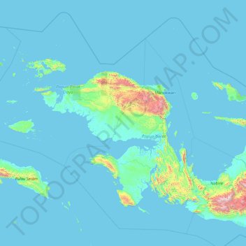
Name: West Papua topographic map, elevation, terrain.
Location: West Papua, Western New Guinea, Indonesia (-4.85172 131.27672 0.56051 135.33417)
Average elevation: 135 m
Minimum elevation: -4 m
Maximum elevation: 3,622 m
Other topographic maps
Click on a map to view its topography, its elevation and its terrain.
lapangan GGM Majalengka
Indonesia > West Java > Majalengka > Majalengka Kulon
Average elevation: 109 m
Puruk Cahu
Indonesia > Central Kalimantan > Murung Raya
Puruk Cahu is crossed by one of the most important rivers in Borneo, Barito River. This town is situated on a hilly land at the northeastern portion of Central Kalimantan. The altitude of this town is actually varied between 70 and 300 metres above sea level. Due to its proximity to the equator, Puruk Cahu…
Average elevation: 46 m