
Kunar Province topographic map
Interactive map
Click on the map to display elevation.
About this map
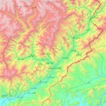
Name: Kunar Province topographic map, elevation, terrain.
Location: Kunar Province, Afghanistan (34.52566 70.57784 35.48194 71.68137)
Average elevation: 2,192 m
Minimum elevation: 569 m
Maximum elevation: 5,359 m
Other topographic maps
Click on a map to view its topography, its elevation and its terrain.
Ghaziabad
Ghaziabad, Kunar Province, Afghanistan
Average elevation: 2,472 m
Asadabad
Afghanistan > Kunar Province > Asadabad
Asadabad, Kunar Province, 2801, Afghanistan
Average elevation: 1,355 m