
Hobart topographic map
Interactive map
Click on the map to display elevation.
About this map
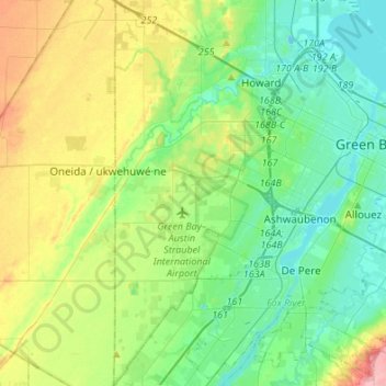
Name: Hobart topographic map, elevation, terrain.
Location: Hobart, Brown County, Wisconsin, 54155, United States (44.39157 -88.19143 44.58447 -88.09707)
Average elevation: 208 m
Minimum elevation: 174 m
Maximum elevation: 286 m
Other topographic maps
Click on a map to view its topography, its elevation and its terrain.
Green Bay
United States > Wisconsin > Brown County
Green Bay, Brown County, Wisconsin, United States
Average elevation: 199 m
Howard
United States > Wisconsin > Brown County
Howard, Brown County, Wisconsin, 54313, United States
Average elevation: 199 m
Ashwaubenon
United States > Wisconsin > Brown County
Ashwaubenon, Town of Ledgeview, Brown County, Wisconsin, United States
Average elevation: 190 m
Anston
United States > Wisconsin > Brown County
Anston, Town of Pittsfield, Brown County, Wisconsin, United States
Average elevation: 225 m