
Moortsele topographic map
Interactive map
Click on the map to display elevation.
About this map
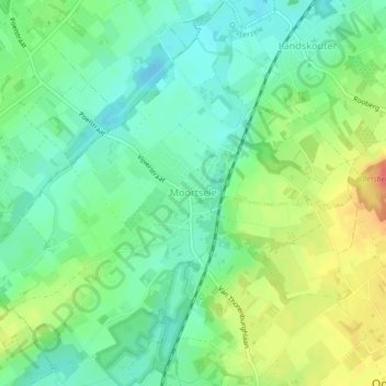
Name: Moortsele topographic map, elevation, terrain.
Location: Moortsele, Oosterzele, Gent, East Flanders, Flanders, Belgium (50.94544 3.75634 50.97266 3.79930)
Average elevation: 30 m
Minimum elevation: 9 m
Maximum elevation: 64 m
Other topographic maps
Click on a map to view its topography, its elevation and its terrain.
Ghent
Belgium > East Flanders > Gent
Ghent, Gent, East Flanders, Flanders, Belgium
Average elevation: 7 m
Deinze
Belgium > East Flanders > Gent
Deinze, Gent, East Flanders, Flanders, Belgium
Average elevation: 10 m
Mariakerke
Belgium > East Flanders > Gent > Ghent
Mariakerke, Ghent, Gent, East Flanders, 9030, Belgium
Average elevation: 7 m
Sint-Martens-Latem
Belgium > East Flanders > Gent
Sint-Martens-Latem, Gent, East Flanders, Flanders, Belgium
Average elevation: 8 m
Drongen
Belgium > East Flanders > Gent > Ghent
Drongen, Ghent, Gent, East Flanders, 9031, Belgium
Average elevation: 7 m
De Pinte
Belgium > East Flanders > Gent
De Pinte, Gent, East Flanders, Flanders, 9840, Belgium
Average elevation: 8 m
Zwijnaarde
Belgium > East Flanders > Gent > Ghent
Zwijnaarde, Ghent, Gent, East Flanders, 9052, Belgium
Average elevation: 9 m
Aalter
Belgium > East Flanders > Gent
Aalter, Gent, East Flanders, Flanders, Belgium
Average elevation: 13 m
Aelmoeseneiebos
Belgium > East Flanders > Gent > Melle > Gontrode
Aelmoeseneiebos, Potaardestraat, Gontrode, Melle, Gent, East Flanders, 9090, Belgium
Average elevation: 23 m
Afsnee
Belgium > East Flanders > Gent > Ghent
Afsnee, Ghent, Gent, East Flanders, Belgium
Average elevation: 7 m
Puyenbroeck
Belgium > East Flanders > Gent > Wachtebeke
Puyenbroeck, Wachtebeke, Gent, East Flanders, Flanders, 9185, Belgium
Average elevation: 4 m
Wippelgem
Belgium > East Flanders > Gent > Evergem
Wippelgem, Evergem, Gent, East Flanders, Flanders, 9940, Belgium
Average elevation: 5 m
Melle
Belgium > East Flanders > Gent
Melle, Gent, East Flanders, Flanders, 9090, Belgium
Average elevation: 13 m
Vinderhoute
Belgium > East Flanders > Gent
Vinderhoute, Lievegem, Gent, East Flanders, Flanders, 9921, Belgium
Average elevation: 6 m
Ghent
Belgium > East Flanders > Gent > Ghent
Ghent, Gent, East Flanders, Flanders, 24-32, Belgium
Average elevation: 12 m
De Pinte
Belgium > East Flanders > Gent > De Pinte
De Pinte, Gent, East Flanders, Flanders, 9840, Belgium
Average elevation: 8 m
Destelbergen
Belgium > East Flanders > Gent
Destelbergen, Gent, East Flanders, Flanders, 9070, Belgium
Average elevation: 6 m
Oosterzele
Belgium > East Flanders > Gent
Oosterzele, Gent, East Flanders, Flanders, Belgium
Average elevation: 36 m
Wachtebeke
Belgium > East Flanders > Gent
Wachtebeke, Gent, East Flanders, Flanders, 9185, Belgium
Average elevation: 4 m
Lochristi
Belgium > East Flanders > Gent > Lochristi
Lochristi, Gent, East Flanders, Flanders, 9080, Belgium
Average elevation: 6 m
Ursel
Belgium > East Flanders > Gent > Aalter
Ursel, Aalter, Gent, East Flanders, Flanders, Belgium
Average elevation: 14 m