
Make a donation
Gear up for your next adventure:
As an Amazon Associate, this site earns from qualifying purchases at no extra cost to you.
Shahuwadi topographic map
Click on the map to display elevation.
Make a donation
Gear up for your next adventure:
As an Amazon Associate, this site earns from qualifying purchases at no extra cost to you.
About this map
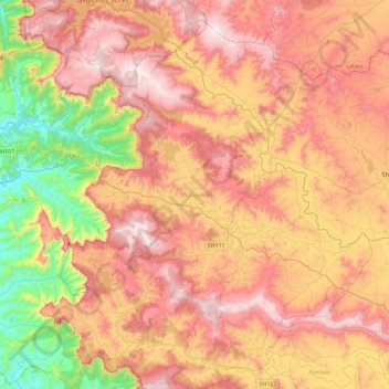
Name: Shahuwadi topographic map, elevation, terrain.
Location: Shahuwadi, Kolhapur district, Maharashtra, India (16.74204 73.68728 17.18134 74.10244)
Average elevation: 601 m
Minimum elevation: 56 m
Maximum elevation: 1,060 m
Make a donation
Gear up for your next adventure:
As an Amazon Associate, this site earns from qualifying purchases at no extra cost to you.
Other topographic maps
Click on a map to view its topography, its elevation and its terrain.
Malkapur
India > Maharashtra > Shahuwadi
Malkapur is located at 16°56′N 73°55′E / 16.93°N 73.92°E / 16.93; 73.92. It has an average elevation of 586 metres (1922 feet).
Average elevation: 581 m
Make a donation
Gear up for your next adventure:
As an Amazon Associate, this site earns from qualifying purchases at no extra cost to you.