
Waldbröl topographic map
Interactive map
Click on the map to display elevation.
About this map
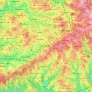
Name: Waldbröl topographic map, elevation, terrain.
Average elevation: 291 m
Minimum elevation: 158 m
Maximum elevation: 423 m
Hailing from Niederbreidenbach near Nümbrecht, Dr. Robert Ley, one of the leading representatives of National Socialism, intended to make Waldbröl the "largest town between Cologne and Kassel". Amongst other things, the so-called Volkstraktorenwerke (National Tractor Plants), an Adolf Hitler School, and a Strength Through Joy (KdF) hotel were projected. Aside from the uncompleted hotel, none of the projects was ever realised. The population figure was meant to increase up to 300,000. It was planned to establish an underground barracks, a theatre, a cinema and a motorway access. Planning continued until autumn 1944 but then got stuck in an early stage due to the course of the war and Ley's waning influence. Only the topographical studies of the garden and landscape designer Wilhelm Heintz, who was already involved in the planning of the "Town Of The Hermann Göring Plants (Salzgitter)" and the "Town Of The KdF Vehicle (Volkswagen Beetle) (Wolfsburg), were finished to a large extent. Apart from some unfinished buildings, only the hotel survived and initially after the war served as hospital, subsequently as school of the German armed forces and since 2006 as 'centre for encounter' of the European Institute of Applied Buddhism. Furthermore, the former architect house of the planned Adolf Hitler School still exists. Since the early 1950s it has served as the country hostel of the Humboldt Grammar School in Düsseldorf.