
Cody topographic map
Interactive map
Click on the map to display elevation.
About this map
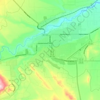
Name: Cody topographic map, elevation, terrain.
Location: Cody, Park County, Wyoming, United States (44.48981 -109.12048 44.55131 -109.00576)
Average elevation: 1,557 m
Minimum elevation: 1,436 m
Maximum elevation: 1,798 m
Cody's elevation is approximately 4,997 feet (1,523 m) above sea level. The main part of the city is split across three levels, separated by about 60 feet (18 m).
Other topographic maps
Click on a map to view its topography, its elevation and its terrain.
Yellowstone National Park
United States > Wyoming > Park County
Yellowstone National Park, Park County, Wyoming, United States
Average elevation: 2,450 m