
Isle of Palms topographic map
Interactive map
Click on the map to display elevation.
About this map
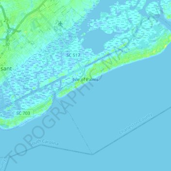
Name: Isle of Palms topographic map, elevation, terrain.
Average elevation: 1 m
Minimum elevation: -3 m
Maximum elevation: 12 m
Other topographic maps
Click on a map to view its topography, its elevation and its terrain.
Wando Estates
United States > South Carolina > Charleston County > Mount Pleasant
Average elevation: 5 m
Forest Trail
United States > South Carolina > Charleston County > Isle of Palms
Average elevation: 1 m
Liberty Hill
United States > South Carolina > Charleston County > North Charleston
Average elevation: 7 m
Saint Andrews Heights
United States > South Carolina > Charleston County > Charleston
Average elevation: 5 m
Camp Saint Christopher
United States > South Carolina > Charleston County > Seabrook Island
Average elevation: 2 m
Ashley Junction
United States > South Carolina > Charleston County > North Charleston
Average elevation: 7 m
Country Club Estates
United States > South Carolina > Charleston County > Charleston
Average elevation: 3 m
Seabrook Island
United States > South Carolina > Charleston County > Seabrook Island
Average elevation: 2 m
North Charleston
United States > South Carolina > Charleston County > North Charleston
Average elevation: 5 m
Northwood Estates
United States > South Carolina > Charleston County > North Charleston > Northwood Estates
Average elevation: 8 m
Deerwood Heights
United States > South Carolina > Charleston County > North Charleston
Average elevation: 8 m
Palmetto Fort
United States > South Carolina > Charleston County > Mount Pleasant
Average elevation: 4 m