
Make a donation
Gear up for your next adventure:
As an Amazon Associate, this site earns from qualifying purchases at no extra cost to you.
Laleham topographic map
Click on the map to display elevation.
Make a donation
Gear up for your next adventure:
As an Amazon Associate, this site earns from qualifying purchases at no extra cost to you.
About this map
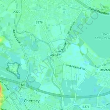
Name: Laleham topographic map, elevation, terrain.
Average elevation: 14 m
Minimum elevation: 7 m
Maximum elevation: 44 m
Surrey trails, hiking, mountain biking, running and outdoor activities
Make a donation
Gear up for your next adventure:
As an Amazon Associate, this site earns from qualifying purchases at no extra cost to you.
Other topographic maps
Click on a map to view its topography, its elevation and its terrain.
Queen Mary Reservoir
United Kingdom > England > Surrey > Borough of Spelthorne > Charlton
Average elevation: 14 m
Shepperton
United Kingdom > England > Surrey > Borough of Spelthorne
Shepperton has a long boundary with the River Thames in its southernmost salient, which almost surrounds Spelthorne. Old Shepperton is almost surrounded by the extreme southern meander within this. Prehistoric glacial retreat north of this has made the north bank almost flat for a considerable distance and as…
Average elevation: 12 m
Sunbury Court Island
United Kingdom > England > Surrey > Borough of Spelthorne
Average elevation: 13 m
Make a donation
Gear up for your next adventure:
As an Amazon Associate, this site earns from qualifying purchases at no extra cost to you.
Shepperton
United Kingdom > England > Surrey > Borough of Spelthorne
Shepperton has a long boundary with the River Thames in its southernmost salient, which almost surrounds Spelthorne. Old Shepperton is almost surrounded by the extreme southern meander within this. Prehistoric glacial retreat north of this has made the north bank almost flat for a considerable distance and as…
Average elevation: 12 m