
Kerang topographic map
Interactive map
Click on the map to display elevation.
About this map
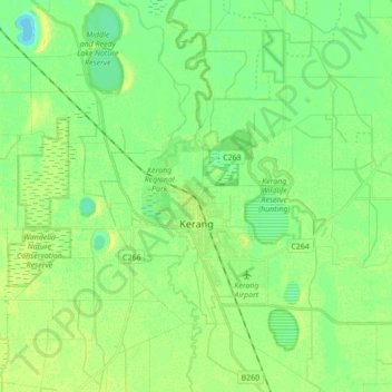
Name: Kerang topographic map, elevation, terrain.
Location: Kerang, Shire of Gannawarra, Victoria, 3579, Australia (-35.78963 143.86118 -35.65858 144.03421)
Average elevation: 78 m
Minimum elevation: 69 m
Maximum elevation: 87 m
Kerang is a town on the Loddon River in northern Victoria in Australia. It is the commercial centre to an irrigation district based on livestock, horticulture, lucerne and grain. It is located 279 kilometres (173 mi) north-west of Melbourne on the Murray Valley Highway a few kilometres north of its intersection with the Loddon Valley Highway, elevation 78 metres (256 ft). At the 2016 census, Kerang had a population of 3,893. Kerang is believed to be an Aboriginal word for Cockatoo. It is home to the largest solar and battery farm in the country which was opened in June 2019. The 50-megawatt battery system is located outside of Kerang and stores 100 per cent renewable energy. The 2,000 solar panels have become a tourist attraction and are drawing many businesses to the town.
Other topographic maps
Click on a map to view its topography, its elevation and its terrain.
Barongarook
Barongarook, Shire of Colac Otway, Victoria, 3249, Australia
Average elevation: 235 m
Paynesville
Australia > Victoria > Paynesville
Paynesville, Shire of East Gippsland, Victoria, 3880, Australia
Average elevation: 8 m
Ferny Creek
Australia > Victoria > Melbourne
Ferny Creek, Melbourne, Shire of Yarra Ranges, Victoria, 3786, Australia
Average elevation: 423 m
Clyde North
Australia > Victoria > Melbourne
Clyde North, Melbourne, City of Casey, Victoria, 3978, Australia
Average elevation: 38 m
Shire of Corangamite
Shire of Corangamite, Victoria, Australia
Average elevation: 151 m
Willow Grove
Willow Grove, Shire of Baw Baw, Victoria, 3825, Australia
Average elevation: 152 m
Gum Swamp, Miepol Wildlife Reserve (no hunting)
Gum Swamp, Miepol Wildlife Reserve (no hunting), Miepoll, Shire of Strathbogie, Victoria, Australia
Average elevation: 139 m
Coronet Bay
Australia > Victoria > Coronet Bay
Coronet Bay, Bass Coast Shire, Victoria, 3984, Australia
Average elevation: 13 m
Strathallan
Strathallan, Shire of Campaspe, Victoria, 3622, Australia
Average elevation: 106 m
Templestowe Lower
Australia > Victoria > Melbourne
Templestowe Lower, Melbourne, City of Manningham, Victoria, 3107, Australia
Average elevation: 55 m
Walkerville
Walkerville, Shire of South Gippsland, Victoria, Australia
Average elevation: 54 m
Mount Buller
Mount Buller, Shire of Mansfield, Victoria, 3723, Australia
Average elevation: 824 m
Warranwood
Australia > Victoria > Melbourne
Warranwood, Melbourne, City of Maroondah, Victoria, 3134, Australia
Average elevation: 131 m
Shepherds Bush
Australia > Victoria > Melbourne
Shepherds Bush, Wantirna South, Melbourne, City of Knox, Victoria, Australia
Average elevation: 76 m
Ringwood North
Australia > Victoria > Melbourne
Ringwood North, Melbourne, City of Maroondah, Victoria, 3134, Australia
Average elevation: 137 m
Warrandyte South
Australia > Victoria > Melbourne
Warrandyte South, Melbourne, City of Manningham, Victoria, 3134, Australia
Average elevation: 106 m
Walkerville North
Australia > Victoria > Walkerville
Walkerville North, Walkerville, Shire of South Gippsland, Victoria, 3956, Australia
Average elevation: 48 m
Wheelers Hill
Wheelers Hill, Shire of Hepburn, Victoria, Australia
Average elevation: 714 m
Cape Paterson
Cape Paterson, Bass Coast Shire, Victoria, 3995, Australia
Average elevation: 29 m
Falls Creek
Australia > Victoria > Falls Creek Alpine Resort
Falls Creek, Falls Creek Alpine Resort, Victoria, Australia
Average elevation: 1,459 m
Falls Creek Alpine Resort
Falls Creek Alpine Resort, Victoria, Australia
Average elevation: 1,491 m
Larnoo Drive Reserve
Australia > Victoria > Melbourne
Larnoo Drive Reserve, Doncaster East, Melbourne, City of Manningham, Victoria, Australia
Average elevation: 69 m
Lancefield
Lancefield, Shire of Macedon Ranges, Victoria, 3435, Australia
Average elevation: 530 m
Dinner Plain
Dinner Plain, Alpine Shire, Victoria, 3898, Australia
Average elevation: 1,397 m
Lake Mountain
Lake Mountain, Shire of Murrindindi, Victoria, Australia
Average elevation: 1,288 m
Mount Beauty
Mount Beauty, Alpine Shire, Victoria, 3698, Australia
Average elevation: 564 m
Korong Vale
Korong Vale, Shire of Loddon, Victoria, 3520, Australia
Average elevation: 149 m
Shire of Murrindindi
Shire of Murrindindi, Victoria, Australia
Average elevation: 447 m
Cranbourne North
Australia > Victoria > Melbourne
Cranbourne North, Melbourne, City of Casey, Victoria, 3977, Australia
Average elevation: 38 m