
Gänserndorf topographic map
Interactive map
Click on the map to display elevation.
About this map
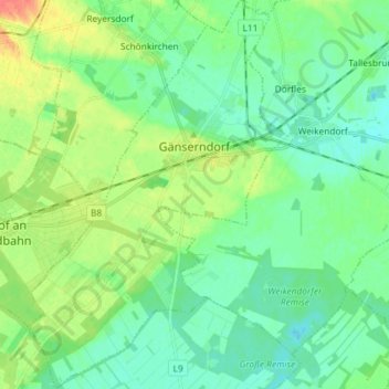
Name: Gänserndorf topographic map, elevation, terrain.
Location: Gänserndorf, Bezirk Gänserndorf, Lower Austria, 2230, Austria (48.28007 16.65651 48.37674 16.75346)
Average elevation: 158 m
Minimum elevation: 144 m
Maximum elevation: 190 m
Other topographic maps
Click on a map to view its topography, its elevation and its terrain.
Hauskirchen
Austria > Lower Austria > Bezirk Gänserndorf > Gemeinde Hauskirchen > Hauskirchen
Average elevation: 194 m
Gänserndorf
Austria > Lower Austria > Bezirk Gänserndorf > Gemeinde Gänserndorf
Average elevation: 343 m