Geolocate

Oslo topographic map

Click on the map to display elevation.

About this map
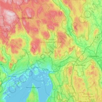
Name: Oslo topographic map, elevation, terrain.

Location: Oslo, Norway (59.80931 10.48917 60.13511 10.95139)

Average elevation: 225 m

Minimum elevation: -1 m

Maximum elevation: 682 m

Other topographic maps

Click on a map to view its topography, its elevation and its terrain.
Oslo

Norway > Oslo

Average elevation: 186 m

Telemark

Norway > Oslo

Average elevation: 10 m

Hardanger

Norway > Oslo

Average elevation: 8 m

Stensrud

Norway > Oslo

Average elevation: 169 m

Huk

Norway > Oslo

Average elevation: 4 m

Prekestolen

Norway > Oslo

Average elevation: 427 m

Gear up for your next adventure:

📦Compression Sacks - Reduce backpack volume efficiently
🛌Sleeping Mats - Insulated mats for comfortable outdoor sleeping
🖼️Topographic Map Art - Decorative 3D-effect posters of famous UK peaks and regions
⛺Camping Shelters - Emergency and lightweight shelters for outdoor use
🧭Professional Hiking Compasses - High-precision liquid-filled compasses for map reading and orientation

As an Amazon Associate, this site earns from qualifying purchases at no extra cost to you.